

Prepared by the Central Sands Water Action Coalition Executive Committee; Skip Hansen, Marty Wilke, and Francie Rowe. CSWAC acknowledges and appreciates technical information supplied by Professor Emeritus George Kraft.
https://centralsandswater.org/ centralsandswater@gmail.com
The Wisconsin Potato and Vegetable Growers Association’s (WPVGA’s) Joe Kertzman got it right in the September 23rd Argus - the levels of lakes and groundwater are way up right now. And though he didn’t say it, so are the levels of wetlands and the flows of streams.
It’s curious that the WPVGA should bring up water levels at this time, as they’ve often deflected attention from lake and stream drying due to high capacity well pumping by claiming water levels barely ever change. We have to wonder: could they be trying to sow confusion in anticipation of the release of DNR’s Central Sands Lakes Study (CSLS)? That study, due for public comment in March 2021 and submission to the legislature on June 1, is supposed to recommend measures that could limit how much water irrigators can pump when unlimited pumping causes fish die offs and lake and stream drying.
More on the CSLS later, but first let’s explore what makes water levels go up and down.
Lakes, streams, wetlands, and groundwater are all connected;
pumping affects them all.
If high capacity groundwater pumping had no effect on lakes, streams, wetlands, and wells, it’s probable that no one would care how much groundwater was pumped out of the ground. But the fact is, groundwater is well connected to surface water and so groundwater pumping matters.
Groundwater is the water under the earth’s surface that saturates the space between sand grains and can be pumped from wells. It originates from local precipitation, on average 31-32 inches per year. Of that precipitation, about 10 inches per year percolates downward through the soil to the top of the water table and become groundwater. Groundwater doesn’t just sit there, but rather moves laterally through the subsurface to nearby streams where it discharges and leaves the watershed. Central Sands groundwater typically flows just a few miles before discharging to a stream.
Lakes and wetlands are formed when low spots on the landscape lie below the water table and become filled with groundwater.
The highs and lows or water level are mostly determined by two factors: precipitation and groundwater pumping. More and less rainfall and snowmelt cause the natural highs and lows, while pumping lowers water levels and streamflows. A little pumping lowers them a little, a lot of pumping lowers them a great deal, as the USGS illustration shows.
Precipitation – Now and Last Century
As WPVGA’s Kertzman correctly stated, the last bunch of years have been amazingly wet: 2019 was the wettest on record, with a whole foot above average precipitation, 2017 was the second wettest, and 2016 was the third. The past 5 and 10 year periods are the wettest recorded. Little wonder that all lakes and streams are up, even those that were decimated by pumping in the earlier 2000s.
Area precipitation shows remarkable trends over the last 80+ years, something that is better illustrated by averaging annual precipitation over 5-year increments. Our region came out of 1930s-era drought to precipitation abundance in the early 1940s. But dry conditions returned and hung on with a vengeance through the 1950s and early ‘60s.
Precipitation since about 1970 has generally trended upward, with wet and dry cycles of about 5-10 years. Presently we are in the wettest year-after-year period on record. Truly dry years have become increasingly rare - the region has not experienced a dry year since 1989 where precipitation was 20% below average. What the future will bring is uncertain. After the peak wet period of the 1940s, the region fell into 20-30 years of dry times.
Kertzman’s article states that lake levels fell after 1980 “…because of 20 years of below-normal rainfall,” but the evidence contradicts this claim. Available DNR and USGS lake and monitoring well records show water levels generally rose through the 1960s and 1970s, and had relatively little fluctuation through the 1980s. Weather records show that 1980s precipitation was mostly average or above average.
But something ominous arose in the early 1990s and persisted through about 2015. Lake and groundwater levels in highly groundwater irrigated areas plummeted and reached record lows during not very dry times. Levels were lower than those of the 1950s drought in areas including Plainfield, Hancock, and Coloma. In areas of less pumping, such as near Wild Rose and Wautoma, levels dipped a little in 2006 to 2010, but they never declined to record drought lows.
Multiple studies have implicated groundwater pumping as the cause.
Groundwater pumping from high capacity wells
High capacity well numbers in our area, mainly for crop irrigation, have exploded over the last decades, and that increase continues. High capacity wells are those capable of pumping at least 100,000 gallons per day but frequently pump over a million gallons per day.
Wisconsin has been stymied in managing groundwater pumping to amounts that still leave us with healthy lakes and streams. Groundwater pumpers are allowed to pump pretty much as they can consume without respect for healthy water bodies and the recreation, property values, fish and wildlife, and tax base they support. This is a fight that’s been going on since the 1950s when only 100 high capacity wells were registered in the Central Sands. Those numbers increased to nearly 500 by 1970, 1300 by 1990, 2000 by 2010, and over 2600 by 2020. Only a handful have received a review to determine if the additional pumping burden would cause too much harm to a lake, stream, or wetland.
High Capacity Well Pumping Explains 1990-2013 Low Water Levels
Long time Long Lake-Oasis dweller Marilyn Williquette recalled that Long Lake never dried before the mid 2000s, even during the extreme drought of the 1950s: “We went fishing and turtle hunting in a rowboat, even with lower water levels during the drought years. I have pictures of us wading during the dry years of the late ‘50s and early ‘60s. The lake never got as dry as it did in 2006 and afterwards, and the fish were never killed out.”
What changed so that water levels and streamflows in Long and the other lakes and streams in the Plainfield, Hancock, and Coloma areas, among others, had low levels or even dried during a not particularly droughty time in the mid to late 2000s, but were wetter during the historic drought of the 1950s and 1960s? Studies show that it was the growth of high capacity wells and groundwater pumping. In the absence of pumping, Long and Plainfield Lakes would not have dried. And lakes like Fish, Huron, Plainfield, and many others would have remained feet higher.
Coming Soon: The Central Sands Lakes Study
Study after study going back to the 1960s has predicted or calculated the impacts of unmanaged groundwater pumping on Central Sands lakes and streams and wetlands. Modern era studies include four performed by UWSP/Extension over 2010-2015, and one by the WGNHS and USGS in 2017 on the Little Plover.
And now another study will be released in the coming months - the so-called “Central Sands Lakes Study (CSLS)”. The study was part of 2018 legislation that gave growers “forever permits” to pump groundwater, and arguably, for the first time in Wisconsin history, the ability to buy and sell the public’s water with land transactions.
The single bright spot in the bill was a study of three lakes - Long, Plainfield, and Pleasant - plus any other lake or stream in the area DNR might think was significantly affected by pumping, and then make recommendations to the legislature for managing nearby pumping. The study probably should have had a list of 20 additional lakes and scores of stream miles included, but rumored pressure from industry whittled the study scope down to just the three named lakes.
The CSLS built on previous Central Sands studies, and is well funded and involves some of the best and brightest hydrogeologists, aquatic biologists, and climatologists in the state and even nation. And though the scope was reduced beyond what legislation involved, we are cautiously optimistic that it will shed light on pumping-impacted water bodies.
The CSLS isn’t the last step in the process laid out by the legislature. Additionally, the DNR is required to recommend management measures to the legislature for ways to allow reasonable amounts of pumping while preventing significant harms to lakes and streams and wetlands, the object being that Plainfield, Long, Pleasant, Fish, Pine, and other surface water bodies do not reach levels as low as 2004-2015 despite average or only modestly dry precipitation conditions.
Whether the legislature takes up DNRs recommendation likely depends on the push they get from industry and water advocates.
CSWAC is not in any way against groundwater pumping. Managing pumping to amounts consistent with healthy surface waters is the key. These last few high precipitation years give us clues as to how groundwater pumping should be managed. During high water and great precipitation years, why limit pumping? However, as precipitation becomes normal or dry, and water levels and streamflows decline to significantly impacted levels, pumping needs to be managed for the benefit of all.
-
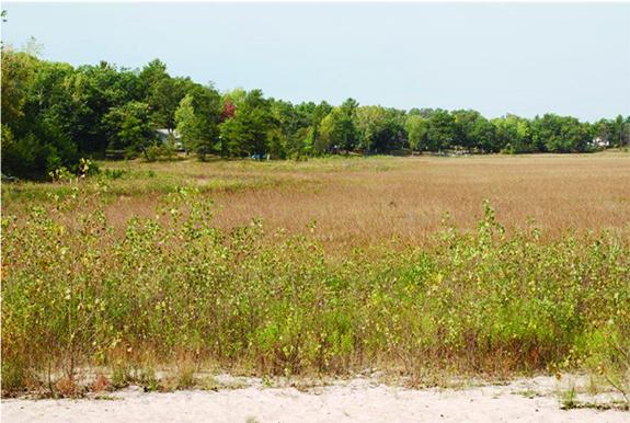 Long Lake - Oasis dried in 2007. (Brian Wolf photograph)